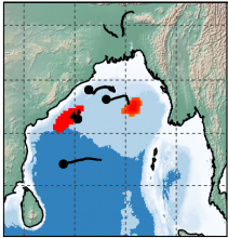
The oceanic eddy parameter information was prepared for 24 years (1993 – 2016) over Bay of Bengal using AVISO. Merged and gridded satellite altimeter product of sea surface height (SSH) anomaly at 7-day interval having special resolution of 0.25o has been used for present study. Mesoscale oceanic eddies have been identified and tracked in weekly merged altimeter product of Sea Surface Height (SSH) from AVISO. Eddies have been identified based on closed contour approach followed by shape criteria. An automated tracking algorithm has been employed to track these eddies with different lifetime. The trajectories of eddies have been computed from their time history. Present method has been used separately for cold core and warm core eddies. There are 24 files each containing weekly eddy data information for individual year.
Data Access
Click Here to access the Science Products . Request to use MOSDAC Single Sign On user credentials to download the data.
Data Version
- Version 1.0 (beta)
Data Sources
- The daily gridded map of Absolute Dynamic Topography data is obtained from AVISO
- ftp site (ftp://ftp.aviso.oceanobs.com)
- Website (http://www.aviso.oceanobs.com/)
Processing Steps
- Remove the long wavelength component of the SSH anomaly and retain the mesoscale features with the wavelength 50-500 km scale.
- Identified outer most closed contour of SSH anomaly.
- The closed contours are sequentially identified, analysed and checked essential criteria.
- Size and amplitude based thresholds for eddy detection were fixed after carrying out several trials.
- Eddies are detected and calculated the eddy parameters.
- Detected eddies are tracked individually.
References
- Chelton, D. B., M. G. Schlax, R. M. Samelson, and R. A. de Szoeke (2007), Global observations of large oceanic eddies, Geophys. Res. Lett., 34, L15606, doi:10.1029/2007GL030812.
Derivation Techniques and Algorithm
- We have followed Chelton et. Al. 2007 in deriving the eddy census in Bay of Bengal with minor modifications in fixing the thresholds for eddy detection specific to this region. This was achieved after performing several trial experiments with different combinations of size and amplitude values.
Limitations
- Accuracy assessment of the dataset has not been carried out. The number of eddies are depending upon the diameter and amplitude threshold. Only mesoscale eddies with maximum diameter of 400km are being considered.
Known problems with data
- Less reliability of SSH data near the coast with altimetry is a known problem.
Related data collections
File Naming Convention
- The typical file name is 'eddy_parameter_YYYY.nc' or ‘YYYY.gif’ where
- 'eddy_parameter’ signifies that this product consists of eddy parameters.
- 'YYYY' corresponds to the year, ex: 2015.
- All the data files are in NetCDF 4 format and the images are in gif format.
MetaData
| Sr. No | Core Metadata Elements | Definition |
| 1 | Metadata language | English |
| 2 | Metadata Contact | MOSDAC |
| 3 | Metadata date | December 12, 2017 |
| 4 | Data Lineage or Quality | Science product of eddy parameters over Bay of Bengal. |
| 5 | Title | Characterizing Ocean Eddy activities in the Bay of Bengal using Altimeter data |
| 6 | Abstract | The oceanic eddy parameter information over Bay of Bengal was prepared for 24 years (1993 – 2016) using AVISO merged and gridded satellite altimeter sea surface height (SSH) data. SSH anomaly at 7-day interval having special resolution of 0.25o has been used for present study. |
| 7 | Dataset Contact | M. Jishad, OSD/AOSG/EPSA, SAC (ISRO), Ahmedabad-380015, India. Ph: +91 79 2691 6117. Email: jishadm@sac.isro.gov.in |
| 8 | Update frequency | - |
| 9 | Access Rights or Restriction | Open Access |
| 10 | Spatial Resolution | 0.25o X 0.25o |
| 11 | Language | English |
| 12 | Topic Category | Physical Oceanography |
| 13 | Keywords | Altimter, sea surface height, Oceanic eddy, Bay of Bengal, Cyclonic and anti-cyclonic |
| 14 | Date or period | January 01 1993 to December 31 2016 weekly data |
| 15 | Responsible Party | Jishad M, Rashmi Sharma and Neeraj Agarwal, Space Applications Centre (ISRO), Ahmedabad-380015, India |
| 16 | Organization | Space Applications Centre (ISRO), Ahmedabad, India |
| 16a | Org. role | Mesoscale oceanic eddies have been identified and tracked in weekly merged altimeter product of Sea Surface Height (SSH) in the Bay of Bengal during the period 1993-2016. |
| 16b | Individual name | M. Jishad, OSD/AOSG/EPSA, SAC (ISRO), Ahmedabad-380015, India. Ph: +91 79 2691 6117. Email: jishadm@sac.isro.gov.in |
| 16c | Position | Scientist/Engineer, OSD/AOSG/EPSA, SAC (ISRO), Ahmedabad-380015, India. Ph: +91 79 2691 6117. Email: jishadm@sac.isro.gov.in |
| 16d | Vertical Extent (minimumValue, maximumValue, unitOfMeasure, vertical datum) | time(time): units = "days since 1950-1-1 00:00:00" : calendar = "Gregorian"; EddyNumber(EddyNumber): “Number of the eddy”; flag(flag): "1 for anticyclonic and 2 for cyclonic"; eddy_id(time, EddyNumber, flag): “eddy id number”; cent_lat(time, EddyNumber, flag): Eddy centre latitude : units = "degree_north"; cent_lon(time, EddyNumber, flag):Eddy centre longitude : units = "degree_east"; amp_ed(time, EddyNumber, flag):Amplitude of the eddy : units = "cm"; sca_ed(time, EddyNumber, flag):Scale of the eddy : units = "km"; are_ed(time, EddyNumber, flag): Area of the eddy : units = "km^2"; |
| 17 | Geographic Extent | Longitude: 78OE to 100O E Latitude : 5ON to 25O N |
| 18 | Geographic name, geographic Identifier | Bay of Bengal |
| 19 | Bounding box | Longitude : 78OE to 100O E Latitude : 5ON to 25O N Resolution : 0.25 O |
| 20 | Temporal Extent | Based on input AVISO data from 1993-2016 (24 years) |
| 21 | Access Rights or Restrictions | Open Access |
| 22 | Distribution Information | Online download of data files in NetCDF format and images in GIF format |
| 23 | Processing Level | Level 4 (Data product derived from The weakly gridded map of Absolute Dynamic Topography data) |
| 24 | Reference System | Projection: Spherical coordinates |


